Weekend weather report: A glimpse of spring before the snow
- Staff Writer

- Feb 26
- 2 min read
Happy Thursday Sea Gulls! Here’s what to expect for the weather heading into the weekend and early next week:
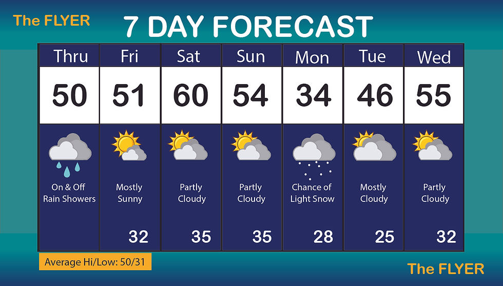
Thursday: Heading out the door this morning there was some fog and cloud coverage, so it made it a little more difficult to see while driving. Today was a gloomy day with rain showers on and off this afternoon. However, this evening the rain should let up and calm down, so if you have any evening plans the rain shouldn’t be an issue.
Friday: Overnight into Friday the clouds will be at a minimal and drying out the air with highs in the upper 40’s maybe even touch into the 50’s. The sun will finally begin to come back out! We will have a SE wind with gusts in the low teens. It will be a breezy day but nothing severe.
Saturday: This is going to be the best day to do any plans and get outside. There is a high of 60 and clear skies all day long. Winds will be on the calmer side again, just overall a great Saturday.
Sunday: There will be a shot of Arctic air that will try to arrive overnight Sunday into Monday ahead of a clipper system that could bring a shot of wintry weather for Monday. Highs dip back down into the low to upper 40’s.
Monday: At the moment, there’s a chance of a snow event that will bring a light accumulation of snow for Monday afternoon and Monday night. However, as we continue to our week for next week, temperatures will begin to rise again so whatever snow accumulation we wake up to on Tuesday, should begin to melt by Tuesday afternoon but definitely by Wednesday.
Summary: After the rain today, temperatures will begin to rise for the weekend with clear, sunny skies. By Monday evening, there’s a small chance of snow, but the temperatures will rebound and there’s even a chance of high 60’s for late next week.
Have a great weekend, Sea Gulls!
By GRACE CONAWAY
Staff Writer


Comments